Ancient Stone Houses and a Volcanic Laboratory: 15 Fascinating Facts About the Northern Mariana Islands
The Northern Mariana Islands hold giant stone foundations, submerged wartime history and a volcanic crater where scientists study changing ocean chemistry. CHamoru and Carolinian traditions connect these islands to a wider Pacific world. These fifteen facts follow the commonwealth from its best-known southern islands toward the remote volcanic north.
1. They share an island chain with Guam, but a different government
The commonwealth comprises fourteen islands in the Mariana archipelago, while Guam forms a separate U.S. territory at the chain's southern end. Saipan, Tinian and Rota are the best-known inhabited islands of the commonwealth. Geography and politics therefore draw different groupings on the same map. A statement about all the Marianas may include Guam, while a statement about the CNMI does not.
2. Their U.S. relationship was negotiated through a covenant
A covenant establishing political union with the United States was signed in 1975 and approved by Congress in 1976. Constitutional government began in 1978, and the covenant came fully into effect in 1986. These stages explain why short histories sometimes offer different dates for the commonwealth's creation. The relationship emerged through a negotiated process rather than the same acquisition history as neighboring Guam.
3. Two Indigenous traditions help shape the islands
CHamoru and Carolinian communities are central to the commonwealth's cultural life. Their histories connect the islands with both the Marianas and wider Micronesian networks. Festivals, language, food and dance carry these traditions into the present. Describing the islands only through the successive colonial powers that administered them would miss the communities whose relationships give the archipelago its enduring identity.
4. Tinian preserves the remains of exceptionally large latte architecture
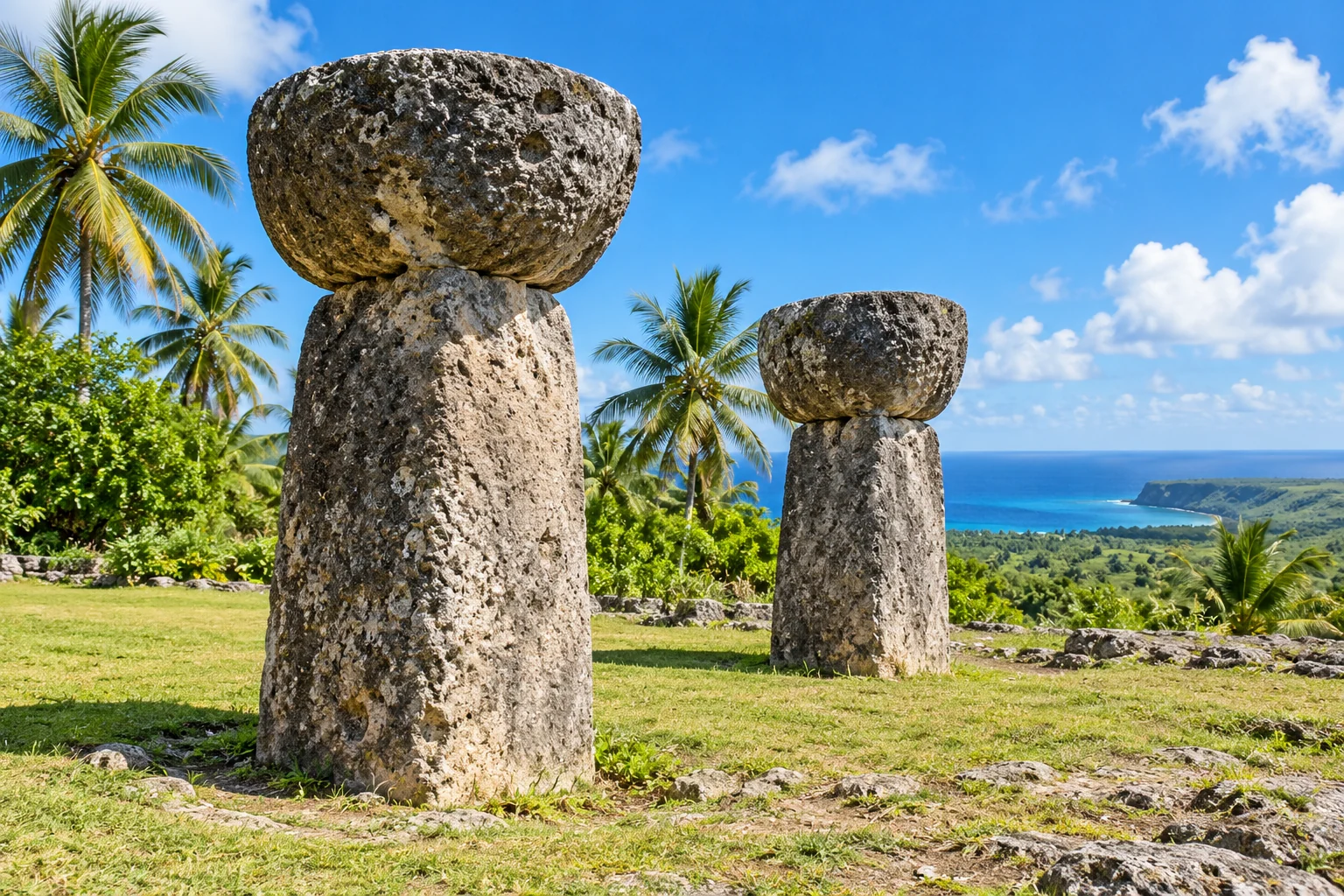
The House of Taga site contains the remains of a great CHamoru building supported on stone shafts and capstones. Its scale helped make it famous, while stories of Chief Taga belong to its cultural interpretation. The standing remnant is only part of the former structure. Archaeology and oral tradition offer different kinds of evidence, both worth recognizing without turning legend into a literal construction record.

5. Rota has an unfinished stone-building project
At As Nieves, huge latte shafts and capstones remain in different stages of quarrying. Their presence shows the work involved before a support could be transported and raised. The precise reason the quarry was abandoned is uncertain. Leaving that question open makes the site more interesting: it preserves a production process interrupted, rather than a completed monument with every stage hidden from view.
6. A Rota cave preserves painted images
Chugai Cave contains dozens of pictographs, including geometric designs and recognizable animals such as marine creatures. These are painted images, distinct from carvings usually called petroglyphs. Their survival adds another material to the islands' cultural record alongside stone foundations and archaeological deposits. The cave's significance also depends on context, which can be lost when individual pictures are treated merely as decorative symbols.
 You might also like
Army Camels and Hawthorne's Friendship: 15 Facts About Franklin Pierce
7. Carolinian navigation carries knowledge across generations
Traditional Carolinian navigation uses stars, swells, winds and other environmental observations to travel across open water. The visitors authority describes the continuing transmission and revival of these maritime skills. Such knowledge joins careful observation with long practice and instruction. The ocean around the islands is therefore also a network of routes and relationships, not simply a wide space separating small patches of land.
8. Saipan's Grotto connects to the sea below the surface
The Grotto is a natural sinkhole with submerged passages linking its blue interior to the ocean. Its dramatic light comes partly from those underwater openings. This is a geological formation with moving seawater, not a sealed swimming pool. The combination of cavern and open-ocean connections explains both its celebrated appearance and why conditions can differ sharply from what a calm-looking surface suggests.
9. The lagoon holds a maritime history trail
Saipan's underwater heritage includes wrecked ships, aircraft and landing vehicles associated with the Second World War. A maritime heritage trail links some of these remains and interprets their history. The objects have also become part of a living marine environment. Looking below the surface reveals another layer of the battle landscape, extending the story beyond the bunkers and memorials visible on land.
10. American Memorial Park remembers civilians as well as servicemen
On Saipan, the Court of Honor lists 5,204 American servicemen who died in the Marianas campaign. A separate Marianas Memorial records 929 CHamoru and Carolinian people who died from war-related causes over the period it commemorates. The two memorials make different losses visible. Together they help prevent the campaign from being remembered solely as a movement of armies across islands.
11. Tinian became a vast base for long-range bombers
After the 1944 battle, airfields on Tinian supported B-29 operations against Japan. North Field retains runways and other remnants of that expansion. The atomic-bomb missions against Hiroshima and Nagasaki departed from Tinian in August 1945. Those associations give a small island an immense place in global history, with a legacy that includes the devastating human consequences of the attacks.
12. Some wartime roads borrowed New York names
American planners compared Tinian's outline with Manhattan and used New York street names in the wartime base. Historic documentation records names including Riverside Drive and Wall Street. The borrowing is an unexpected piece of urban familiarity within a Pacific military landscape. It also shows how a rapidly built installation could impose a new working map over an island that already had its own places and histories.
13. Pagan is made from two volcanoes
Pagan consists of two stratovolcanoes joined by a narrow isthmus. North Pagan has produced most of the island's recorded eruptions, including the major 1981 event that prompted evacuation. The island is a reminder that the northern Marianas are an active volcanic chain. Their landscapes are still developing, with geological activity carrying real consequences for communities and their connections to home.
14. Three Maug islets are the rim of one flooded caldera
Maug's steep islands mark parts of a volcanic crater rim that rises above the sea. Water fills the central caldera, while reefs grow in portions of this unusual setting. The apparently separate islets therefore belong to one underlying volcanic structure. Reading the seafloor along with the shoreline reveals a landscape much more continuous than a simple map of dry land suggests.
15. Maug's gas vents create a natural research laboratory
Carbon dioxide escaping underwater at Maug changes the chemistry of nearby seawater. Scientists study how corals and other organisms respond across the resulting local gradients. Conditions near the vents differ from those farther away, providing a rare opportunity for field comparison. The site helps researchers investigate ocean acidification while observing a reef ecosystem directly, rather than reproducing every condition inside a laboratory tank.
How did these facts land?
Know someone who'd love these facts? Share them 👇